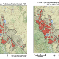
Habitat models are important tools in identifying key areas utilized by Bi-State sage-grouse based on habitat characteristics, telemetry locations and vital rate data. The Bi-State sage-grouse habitat map is based on two well-accepted modeling approaches: resources selection functions (RSFs) and utilization distributions (UDs). RSFs and UDs were used to identify areas important to these populations based on associations with certain environmental characteristics and space use by sage-grouse respectively.
Conservation and Management Tools
The USGS prepared these population and habitat analyses in cooperation with the U. S. Fish and Wildlife Service, Bureau of Land Management, California Department of Fish and Wildlife, Nevada Department of Wildlife, and the U.S. Forest Service.
These analyses provide current and best available science regarding population status of sage-grouse within the Bi-State DPS. Using data from a long-term monitoring program, they carried out six analytical study objectives.

Bi-State partners have collaborated to conduct extensive monitoring of sage-grouse populations within the Bi-State DPS. Data regarding lek attendance, movement, and survival of sage-grouse across multiple life stages were documented. Specifically, sage-grouse from nearly all subpopulations were marked and tracked across multiple seasons using radio-telemetry techniques.

Bi-State sage-grouse are strongly affected by conifer expansion, annual grass invasion, and more frequent wildfires occurring in sagebrush ecosystems. Associated restoration treatments to a sagebrush‐dominated state are often costly and may yield relatively little ecological benefit to sage‐grouse if implemented without estimating how sage‐grouse may respond to treatments, or do not consider underlying processes influencing sagebrush ecosystem resilience to disturbance and resistance to invasive species.